If
you don't see a menu below, please click on the above logo.
Cape Dory Sailboat Owners
Association
CDSOA Maine
Cruise Cape Dorys and the
Beautiful Islands of Penobscot Bay August
16-21, 2004
Click
here for a printer-friendly version of this document. (PDF
2.48 MB)
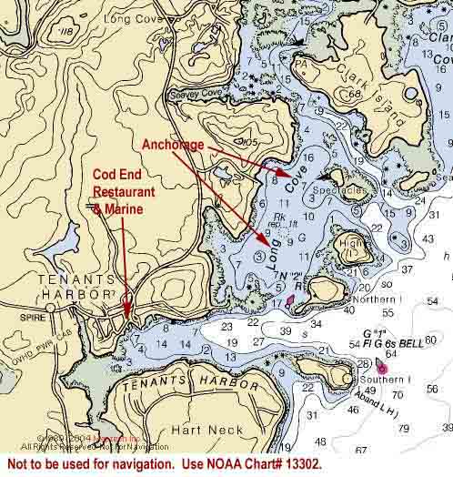
Monday, 8/16--Long Cove, Tenants Harbor
Click on chart thumbnail
for details.Visit
MapTech.com! Figure 1.Long Cove, Tenants Harbor
Not to be used for navigation. Use NOAA
Chart# 13302.
Plan on meeting in Long Cove at Tenants
Harbor in the afternoon on Monday, August 16th
where Liberty, Cruise Captain
Stephen Files’ CD36, will be waiting for your
arrival.
The entrance to Tenants Harbor is approximately 12.4 nm north-northeast
of Monhegan Island and 16 nm west-southwest of Vinalhaven in
Penobscot Bay. The anchorage is broad, shallow, tranquil and
easily entered between RN “2” west
of Northern Island and the ledge that juts
out from the mainland. Stay close to the nun as you enter.
If conditions permit, let's form a raft-up. And once settled,
we'll get together on one boat or the raft for snacks, cocktails
and dinner. Bring one or two snack items to share with the rest
of the group and the fixin's for your favorite beverage. Then
it's potluck for dinner. No, we don't throw everything into
one pot and whatever comes out is dinner (unless you want to).
But whatever you bring it’s what we'll have.
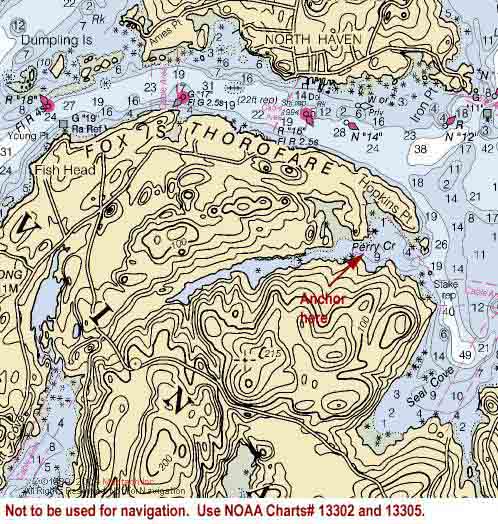
Tuesday, 8/17--Perry Creek, Vinalhaven – 19.6 nm
Click on chart thumbnail
for details. Visit
MapTech.com! Figure 2. Perry Creek, Vinalhaven
Not to be used for navigation. Use NOAA
Charts# 13302 and 13305.
It should be a leisurely sail from Tenants Harbor to Vinalhaven
where we’ll pull into Perry Creek off Fox Islands
Thorofare.
Perry Creek is a beautiful and well-protected anchorage guarded
by the picturesque little Mouse Island off
Hopkins Point. It’s also very popular,
so we’re going to try to get there as early as we can.
A substantial unmarked ledge extends southward from Mouse Island
for a distance about equal to the length of the island and there’s
another ledge protruding northward from the south shore of Perry
Creek so stay halfway between Mouse Island and the south shore
when entering the creek.
Anchor just west of the cable area in 8 to 11 feet of water
at low tide. Holding ground is good in mud. Mean tidal range
is about 9.5 feet. There are also a number of private moorings
which are usually available if you arrive early. Across the
way, east of the ferry landing, J.O. Brown & Sons,
Inc. (Ch. 16; 207-867-4621) has a number of inexpensive
moorings. They also have gas, diesel, water and ice as well
as a chandlery. And at North Haven (we passed it along the way
in Fox Islands Thorofare) there is a small grocery store and
showers.
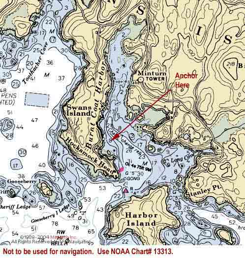
Wednesday, 8/18--Burnt Coat Harbor, Swans Island – 19.4
nm
Click on chart thumbnail
for details. Visit
MapTech.com! Figure 3. Burnt Coat Harbor, Swans Island
Not to be used for navigation. Use NOAA
Charts# 13313.
From Perry Creek our next stop is another pretty and well-protected
harbor -- Burnt Coat Harbor on the south shore of Swans Island.
It is the quintessential down east working harbor, not to be
missed.
You can anchor north of Hockamock Head Light
on the western side of the harbor outside the mooring field
in 17-25 feet at low in mud and seaweed, but the holding isn’t
very good. Moorings are available from the Swans Island
Boathouse (207-526-4207). Fuel is available at Fisherman’s
Co-op and Kent’s Wharf (Ch. 68, 207-526-4186)
if you need it and, of course, they’ve got lobsters as
well. If you need fuel, make sure you get it before 1 p.m.
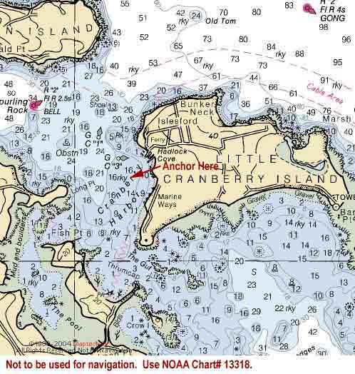
Thursday, 8/19--Little Cranberry Island – 19.7 nm
Click on chart thumbnail
for details. Visit
MapTech.com! Figure 4. Cranberry Harbor, Little Cranberry Island
Not to be used for navigation. Use NOAA
Charts# 13318.
Our next destination is Cranberry Harbor,
nestled between Great and Little Cranberry Islands, about 2
nm south of Mount Desert Island affording spectacular views
of the mountains to the north.
The best protection is found in Hadlock Cove,
the wide bight where the docks are located, on Little
Cranberry Island. The Islesford Dock Restaurant
(207-244-7494) has several guest moorings and the Little
Cranberry Yacht Club has a couple available for rental as well
(first-come, first-served) but there is plenty of room to anchor
outside the mooring field in 14-23 feet at low in kelp. If the
weather isn’t cooperating we’ll head for Northeast
Harbor, on Mount Desert Island, instead.
There are public restrooms on Little Cranberry in the Blue
Duck, an outbuilding at the head of the dock owned
by the National Park Service. The Islesford Historic
Museum, part of Acadia National Park, is in the Georgian
brick and granite building close to the docks. And a short walk
eastward on the main road will bring you to the Islesford
Market (207-244-7667).
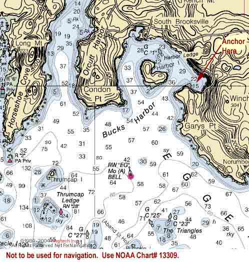
Friday, 8/20--Bucks Harbor, South Brooksville – 27.7 nm
Click on chart thumbnail
for details. Visit
MapTech.com! Figure 5. Bucks Harbor, South Brooksville
Not to be used for navigation. Use NOAA
Charts# 13309.
Bucks is a great little harbor sitting on the north shore of
the western end of Eggemoggin Reach.
NOTE: The markers in Eggemoggin
Reach are ordered from east to west. When entering the reach
from the east, keep cans to port and nuns to starboard.
The channel in Bucks leads you around Harbor Island.
You can anchor on any side of the island but shoals extend about
250 yards off the northeast side of the island. Harbor
Ledge is marked by GC “1”.
Lem’s Cove also offers good protection.
There are moorings which can be reserved ahead of time available
from Bucks Harbor Marine (Ch. 9 or 16, 207-326-8839)
or the Bucks Harbor Yacht Club (207-326-9265).
There is a steel band which plays on occasion. Bucks Harbor
Marine is great and features the best Key Lime Pie on the Maine
coast. They also have fuel, water, ice and some marine supplies
but they will charge you for water. The Bucks Harbor
Market (207-326-8683) sits at the one and only intersection
in South Brooksville. It has a lunch counter, pizza, groceries,
baked goods, produce, cheese, wine and beer in case you’re
running low on provisions.
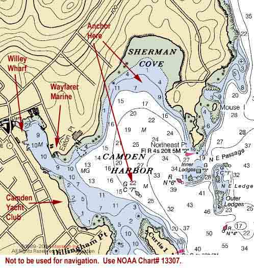
Saturday, 8/21--Camden – 15.2 nm
Click on chart thumbnail
for details. Visit
MapTech.com! Figure 6. Camden
Not to be used for navigation. Use NOAA
Charts# 13307.
Camden is the cruisers’ classic, a real jewel, filled
with cruising yachts and weathered windjammers and the perfect
place to end our cruise. We hope you enjoyed sailing with us.
We recommend that you make your reservations for a mooring
in advance. Please contact Wayfarer Marine (Ch. 9/71,
207-236-4378) or Willey Wharf (207-236-3256).
Wayfarer Marine is a major, full-service yard and fuel, water,
ice and pump-out are available as well as launch service, showers,
laundry facilities and a marine store. Willey’s can refill
CNG and propane tanks, and provide water, ice and showers. If
you need provisions, head for French and Braun (207-236-3361),
located downtown, for meats, produce and baked goods.
Moorings:
$30.00 per night Float: $35.00 per night Dockside (rafted): $3.00 per foot
If you’d rather drop the hook, anchorage in Camden Harbor
is best on its westernmost side, between Eaton Point
and Curtis Island north of GC “7”
or in the outer part of Sherman Cove. The ground
is soft and you’re well-protected. Hail the harbormaster
(Ch. 9) for available moorings in busy Inner Cove.
There’s alot to see and do in Camden, so start out by
visiting the Chamber of Commerce, in the little house at the
public landing in the heart of town, or by taking a walk.
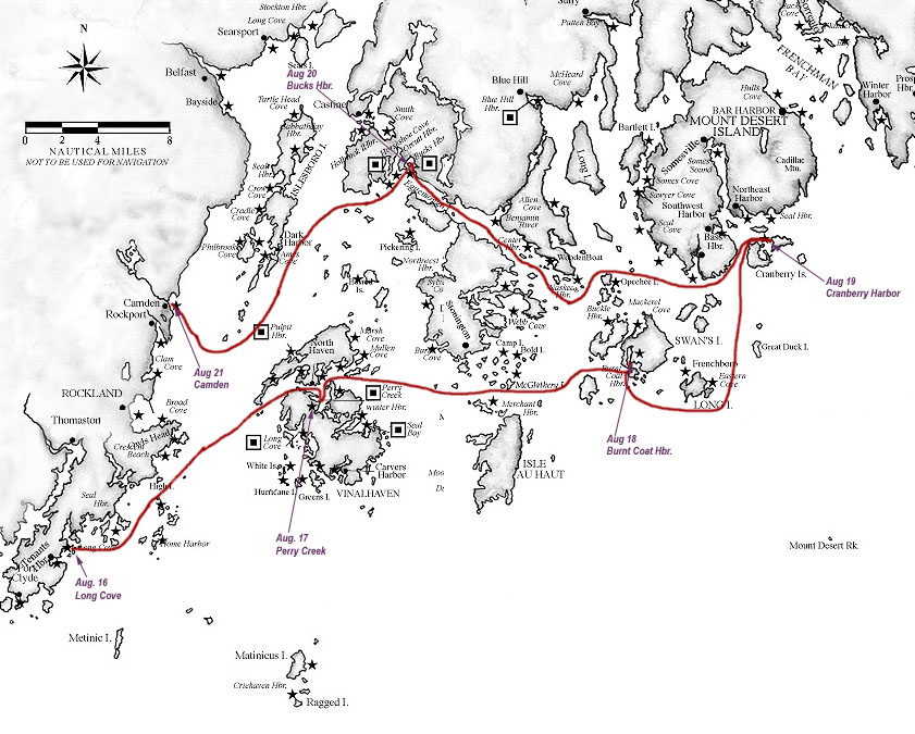
Click on chart thumbnail
to see the entire route. Figure 7. The Route
Fees
Entry Fee (per boat) if received before July 30th:
CDSOA Members: FREE Non-CDSOA Members: $5.00
Late Entry Fee (per boat) if received after July
30th:
CDSOA Members: $5.00 Non-CDSOA Members: $10.00
Rendezvous T-shirts: $20.00
each available in adult sizes: S, M, L, XL, XXL
Register NOW
by downloading either the Microsoft
Word (70 KB) or PDF
(70 KB) version of the Registration Form, printing
and completing the form, and sending the completed form, along
with your check, to the name and address indicated at the bottom
of the form.
All owners of both Cape Dory power and sailboats,
CDSOA members and non-members, are welcome to attend.
All captains are responsible
for their own navigation and the safety of their vessels and crew.
If you have any questions regarding this event,
please contact Cruise Captain Stephen Files, 413-584-0033
or at neastsail@aol.com
or Fleet Captain Catherine Monaghan, 732-381-3549 or at
c_m_monaghan@comcast.net.
Please check this page often as we will include more information
as it becomes available.
Please see the "Events" page
for the current Northeast Fleet Rendezvous agenda.
For information on becoming part of the Northeast
Fleet see the "Fleet Information."