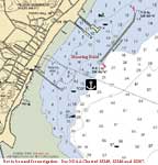
Monday, 8/15--Provincetown, MA
Click on chart thumbnail
for details. Visit
MapTech.com!
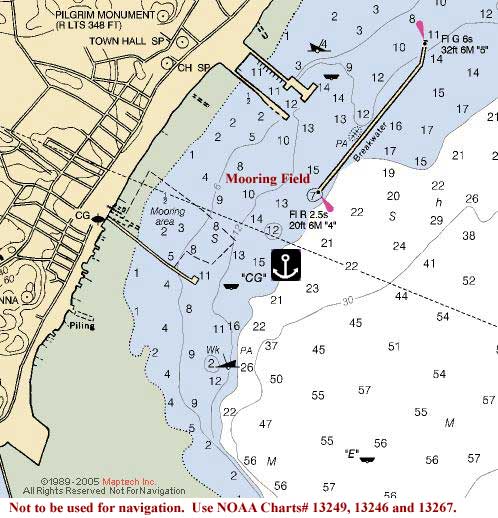
Figure 1. Provincetown Harbor, MA
Not to be used for navigation. Use NOAA
Chart# 13249, 13246 and 13267.
Fleet communications will be on VHF Ch. 16 and
68.
Plan on meeting in the anchorage of Provincetown
Harbor in the afternoon on Monday, August 15th
where Cruise Captains Cathy Monaghan and Bruce Halley
will be waiting aboard their CD32 Realization
for your arrival. Anchor just outside the mooring field
southwest of the breakwater or reserve a mooring from the Provincetown
Marina (508-487-0571, VHF Ch. 9) or Provincetown
Mooring Services (VHF Ch. 9).
Entering Provincetown Harbor is easy as the harbor is wide
and deep. If you're coming from the outside, give Race Point
a wide berth. From any direction your first mark will then be
Fl G 4s BELL G"1" south of Wood End.
Head for Q G BELL G"3" east of Long
Point, leaving it to port before heading into the harbor. The
breakwater is approximately 26.1 nm from the entrance to Plymouth
Bay, approximately 21.3 nm from QG BELL G"3" at the
entrance to the Cape Cod Canal, and 27 nm from the Wellfleet
breakwater light Fl R 2.5s 16ft 5M "14".
Use tide tables for Boston. High tide in Provincetown is 16
minutes later and low tide is 18 minutes later. Mean tidal range
is about 9 feet.
In the evening we'll all gather on one of the boats for cocktails.
So bring one or two snack items to share with the rest of the
group in the anchorage and the fixin's for your favorite beverage.
Then it's potluck for dinner. No, we don't throw everything
into one pot and whatever comes out is dinner (unless you want
to). But whatever you bring it’s what we'll have.
Tuesday, 8/16--Scituate, MA – 30 nm
 Click on chart thumbnail
for details. Visit
MapTech.com!
Click on chart thumbnail
for details. Visit
MapTech.com!
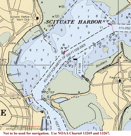
Figure 2. Scituate Harbor, MA
Not to be used for navigation.
Use NOAA Chart# 13269 and 13267. It should be a leisurely sail or motor northwestward from Provincetown
to Scituate.
Here we'll have to get moorings, so contact Scituate
Launch (781-545-4154, VHF Ch. 9)
Scituate Harbor, which is centrally located in Cape Cod Bay,
is an easy daysail from Plymouth Bay (15 nm) or the Canal (28.5
nm), from Provincetown (29.9 nm), or from Boston Harbor (19.3
nm), making it a nearly automatic stop on any regional itinerary.
This also means that Scituate is a very busy and full harbor.
So be sure to call ahead for your mooring.
A good marker to pick up midway between Race Point off Provincetown
and Scituate is Mo(A) WHIS RW "H".
From there it's an easy run northwesterly to Mo(A) GONG
RW "SA" about 8.5 nm away. The channel is
well marked so navigation is easy but don't leave the channel
until you're well past the jetties.
Use tide tables for Boston. High tide in Scituate is 3 minutes
earlier and low tide is 2 minutes later. Mean tidal range is
about 9 feet.
Once everybody has settled in, we'll gather aboard one of the
boats again for evening snacks, cocktails and another potluck.
If you'd rather have dinner ashore or on your own that's okay
too.
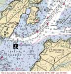
Wednesday, 8/17--Salem, MA – 24 nm
Click on chart thumbnail
for details. Visit
MapTech.com!
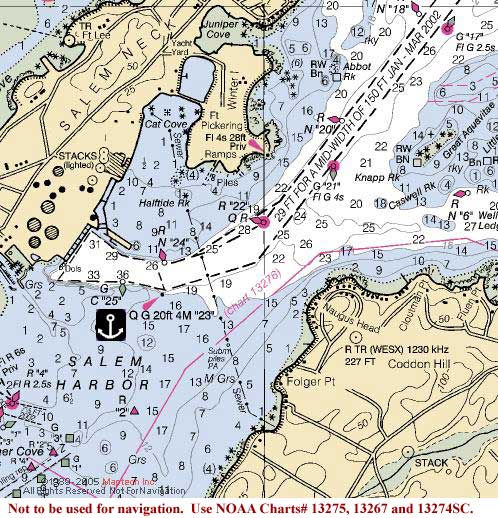
Figure 3. Salem Harbor, MA
Not to be used for navigation. Use NOAA
Charts# 13275, 13267, 13274SC and 13276.
From Scituate we'll continue northward to
Salem where we'll anchor just outside the channel between
Q G"23" and G C"25". If you want to go ashore,
contact Pickering Wharf Marina (978-744-2727,
VHF Ch. 9) or Salem Water Taxi
(978-745-6070, VHF Ch. 68) for launch service.
If you'd rather get a mooring or slip, try nearby Hawthorne
Cove Marina (978-740-9890, VHF Ch. 9).
The anchorage in Salem Harbor is approximately 24 nm from Scituate
and 15 nm from President Roads, the entrance to Boston Harbor.
We will make the approach into Salem Harbor via Marblehead
Channel. Stay in the channel and do not cross Middle Ground
as this entire area is peppered with rocks and ledges as well
as lobster pot buoys. Cross Salem Sound and pick up Salem Channel
where you'll head for G"13" Fl G 4s and follow the
channel into Salem Harbor. Leave the channel between Green markers
"23" and "25" and anchor.
Use tide tables for Boston. High tide in Salem Harbor is 4
minutes later and low tide is 3 minutes later. Mean tidal range
is about 9 feet.
Once again we'll gather aboard one of the boats for evening
snacks, cocktails and another potluck. If you'd rather have
dinner ashore or on your own that's okay too. Or we can decide
as a group what we want to do for dinner.
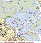
Thursday, 8/18--Cohasset, MA – 19 nm
Click on
chart thumbnail for details. Visit
MapTech.com!
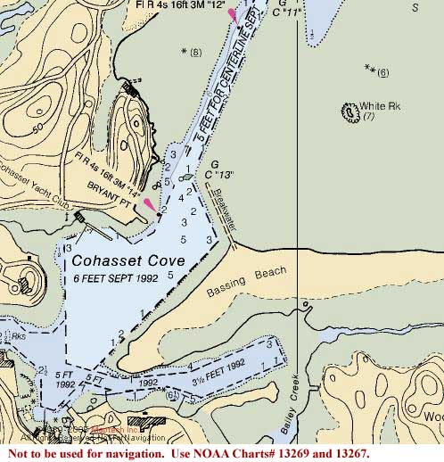
Figures 4 and 5. Cohasset Harbor and Cohasset Cove.
Not to be used for navigation. Use NOAA
Charts# 13269 and 13267..
Then from Salem we turn around and start heading back stopping
at Cohasset approximately
19 nm to the south. If the weather prediction is for settled
weather all night, we'll anchor in outer Cohasset Harbor just
east of the entrance to the channel. If it looks like the weather
won't cooperate, we'll contact the Harbormaster
(781-383-0863, VHF Ch. 11) to see if there
are any available moorings otherwise we'll continue on to Scituate.
Enter Cohasset Harbor using Western Channel.
This is another place be vigilant, to check your charts carefully
and keep an eye on your plotter -- more rocks. Pass between
G C"3", west of Chittenden Rock, and R N"4"
marking Buckthorn Rock. From between these aids, keep G"5",
marking Barrel Rock, to the south and then the west. Give it
plenty of room before heading south and passing east of R N"6W"
at Sutton Rocks on the way to the harbor, then drop your hook
in the anchorage in the outer harbor.
Use tide tables for Boston. High tide in Cohasset Harbor is
4 minutes later and low tide is 2 minutes earlier. Mean tidal
range is about 9 feet.
Once again we'll gather aboard one of the boats for evening
snacks, cocktails and another potluck. So don't forget to bring
your favorite snacks, "dish" and beverages.
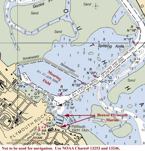
Friday, 8/19--Plymouth, MA – 22.5 nm
Click on chart thumbnail
for details. Visit
MapTech.com!
Figure 6. Plymouth Harbor
Not to be used for navigation.
Use NOAA Chart# 12343 and 12347.
Friday morning we'll leave Cohasset and sail to Plymouth.
The entrance to Plymouth Harbor is just about 18 nm south of
Cohasset then another 4.5 nm to the mooring field deep inside
the harbor. Here we'll need moorings again. You can contact
either Brewer Plymouth Marine (508-746-4500,
VHF Ch. 9) or the Plymouth Yacht Club
(508-746-7207 for the office, VHF Ch. 8,
508-747-0473 for moorings).
The harbor channel, though long, is very well marked, so you
won't have any trouble getting in.
Let's try to get ashore and share a final dinner together at
the Mayflower Restaurant right there at Brewer's.
Fees:
Entry Fee (per boat):
CDSOA Members: FREE
Non-CDSOA Members: $5.00
(pay at the event)
Please
register online by August 8th!
Web Resources:
Boston
Sailing Center Cruising Guide
Motor
Boating Magazine
Cohasset Chamber of
Commerce
|