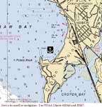
Thursday, 7/14--Croton-on-Hudson
Click on chart thumbnail
for details. Visit
MapTech.com!
Figure 1. Croton Point, Croton-on-Hudson,
NY
Not to be used for navigation. Use NOAA
Chart# 12343 and 12347.
Fleet communications will be on VHF Ch. 16 and
68.
Plan on meeting in the bight north of Croton Point
in the afternoon on Thursday, July 14th where
Cruise Captains Cathy Monaghan and Bruce Halley
will be waiting aboard their CD32 Realization
for your arrival.
When rounding Croton Point, stay well south of the charted
shoal area which extends south from the tip of the point. As
you round the point, give Potato Rock and other obstructions
on the north side of the point a wide berth.
We'll be anchored right off Croton Point Park. If you'd like
to go ashore, make sure you've got your dinghy. The landing
area is east of the anchorage, east and north of the swimming
area which is marked by floats connected by a line. Do not bring
your dinghy into the swimming area! Landing is not permitted
west of the swimming area.
In the evening we'll all gather on one of the boats for cocktails.
So bring one or two snack items to share with the rest of the
group in the anchorage and the fixin's for your favorite beverage.
Then it's potluck for dinner. No, we don't throw everything
into one pot and whatever comes out is dinner (unless you want
to). But whatever you bring it’s what we'll have.
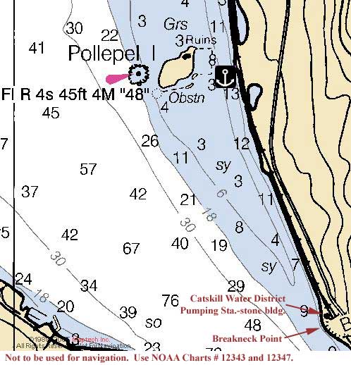
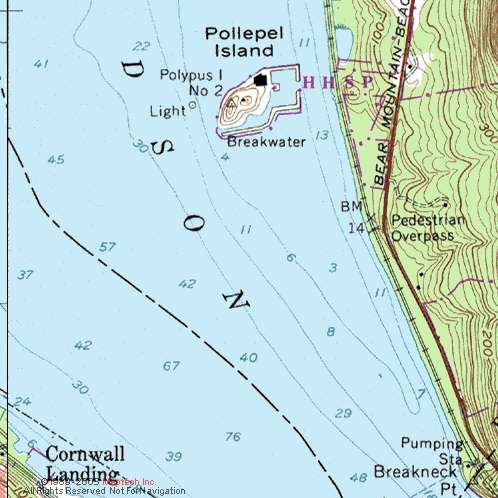
Friday, 7/15--Pollepel Island– 22.3 nm
Click on chart thumbnail
for details. Visit
MapTech.com!
Figures 2 and 3. Pollepel Island
Not to be used for navigation.
Use NOAA Chart# 12343 and 12347.
It should be a leisurely sail or motor north from Croton Point
to Pollepel Island where we’ll pull into the anchorage
just east of the island.
Pollepel Island, also known as Bannerman's Island, marks the
northern approach to the highlands about a mile north of Storm
King Mountain. The Bannerman's built a castle on the island
in the early 1900s, the ruins of which remain to this day. Landing
is not permitted on the island but it's a nice place
to watch the sunset and take in the beauty of the area.
South of the island a deep water channel runs along the eastern
shore. To reach the anchorage which is southeast of the island,
from the south head towards the stone building, the Catskill
Water District's pumping station, just north of Breakneck Point.
As you near shore, turn north and follow the deepest water toward
the island. Anchor in 10+ feet of water. Do not pass between
the island and the shore since piles and other obstructions
extend east from the island. Leave the island by reversing your
path.
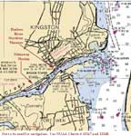
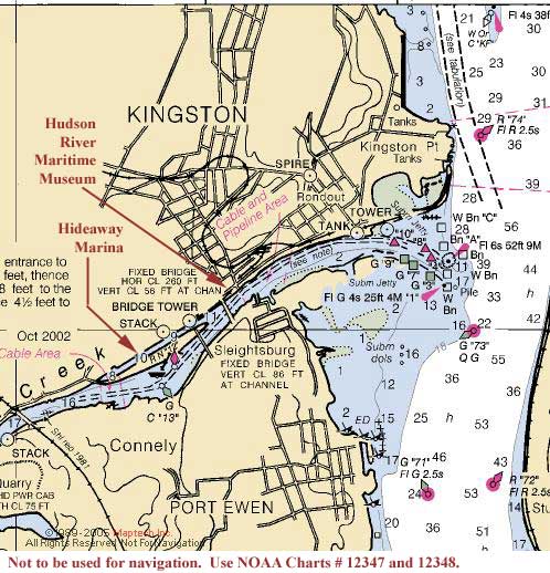
Saturday and Sunday, 7/16-7/17--Rondout Creek, Kingston –
34.2 nm
Click on chart thumbnail
for details. Visit
MapTech.com!
Figure 4. Rondout Creek, Kingston, NY
Not to be used for navigation. Use NOAA
Charts# 12347 and 12348.
From Pollepel Island we'll head north for Rondout Creek and
the City of Kingston
where we'll spend the remainder of Saturday and all day Sunday
tied up at the Hideaway Marina, Rt 213 (170
Abeel St.), phone: 845-331-4565
or 845-331-4665 (hail on VHF Ch. 16).
If you can't
participate in the cruise, by all means drive up to Kingston
on Sunday and say hello or join us for dinner.
The creek is both industrial and scenic and the city is historic.
Kingston is a chronology of American architecture spanning four
centuries from the early Dutch and English, including Federalist,
Georgian, Greek Revival, Victorian, Romanesque, Italianate,
Neo-Classical, Art Deco and Contemporary. The blend makes a
beautiful landscape for every visitor.
The Dutch first settled the region in 1653. At the time of
the Revolutionary War, Kingston was the colonial capital of
New York State and the British burned the city to the ground
in 1777 as a diversion to the Battle of Saratoga. But, the fire
didn't burn everything and there are several pre-Revolutionary
War buildings still standing and occupied including the original
state house which is now a museum.
In 1828 the Delaware and Hudson Canal was completed between
Eddyville, just west of Kingston on Rondout Creek, to Honesdale,
Pennsylvania, making Kingston an important transportation and
commercial center.
We'll explore the town; it's small so it shouldn't take long
but there are interesting things to see and do. There are several
art galleries, shops and restaurants in the waterfront area.
There's also the Urban Cultural Center, Trolley Museum, and
Hudson River Maritime Museum Center all within walking distance
of the marina. Or we could hop on a boat and take a guided tour
of the Rondout Lighthouse, a historic 1913 lighthouse located
on the Hudson River at the mouth of Rondout Creek; we'll pass
it when we enter the creek.
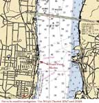
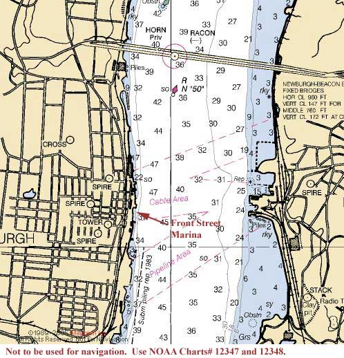
Monday, 7/18--Newburgh– 31.8 nm
Click on chart thumbnail
for details. Visit
MapTech.com!
Figure 5. Newburgh, NY
Not to be used for navigation. Use NOAA
Charts# 12347 and 12348.
Then from Kingston we head south to our next destination, Newburgh,
NY.
Newburgh also sits on the Hudson's western shore with rows
of Victorian homes overlooking the river. The waterfront downtown
area was newly redeveloped in 2002 and includes the new Front
Street Marina, shops and restaurants. Situated in a
park-like setting, complete with a scenic riverwalk, the Front
Street Marina (845-661-4914 or 914 850-5542,
VHF Ch. 9 & 16) is located
just south of the Newburgh/Beacon Bridge
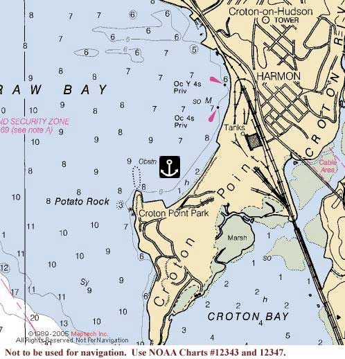
Tuesday, 7/19--Croton-on-Hudson – 29.8 nm
Click on chart thumbnail
for details. Visit
MapTech.com!
Figure 6. Croton Point, Croton-on-Hudson
Not to be used for navigation.
Use NOAA Chart# 12343 and 12347.
Tuesday morning we'll leave Newburgh and return to our starting
point, Croton-Point, about 30 nm to the south where we'll anchor
again.
Let's try to get ashore and share a final potluck dinner in
the park.
Fees
Entry Fee (per boat):
CDSOA Members: FREE
Non-CDSOA Members: $5.00
(pay at the event)
Please
register online by July 9th!
|