The Eastern Long Island Sound Float-in, hosted by the Northeast
Fleet, will take place Saturday and Sunday, August 27-28,
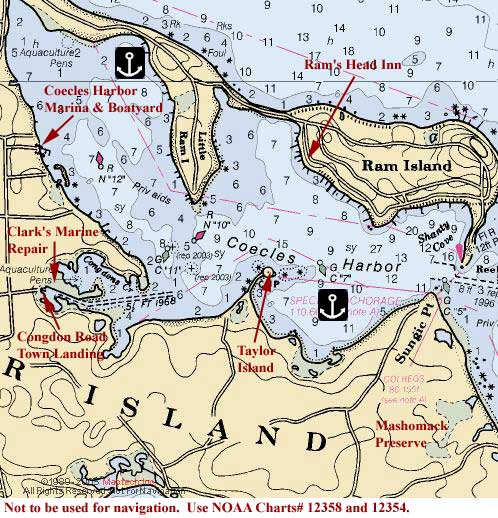
2005 at Coecles Harbor, Shelter
Island, NY. Try to arrive as soon as possible on Saturday
to ensure that you'll find room to anchor.
 We'll
be meeting in Coecles Harbor, 6.5 nm south-southwest
of Plum Gut, on the SOUTH side of the harbor in the "Special
Anchorage" between Sungic Point and the "cupola".
Be careful to stay within the marked channel when entering the
harbor and keep in mind that there is a strong current. Coecles
Harbor has generally good holding ground in grass and mud.
We'll
be meeting in Coecles Harbor, 6.5 nm south-southwest
of Plum Gut, on the SOUTH side of the harbor in the "Special
Anchorage" between Sungic Point and the "cupola".
Be careful to stay within the marked channel when entering the
harbor and keep in mind that there is a strong current. Coecles
Harbor has generally good holding ground in grass and mud.
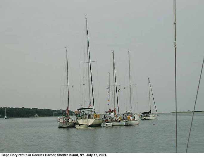
If conditions permit, we can try a raft-up. (Rafting is optional
and up to the discretion of each captain.)
If you'd rather have a mooring, moorings are available from
the Ram's
Head Inn (631-749-0811), located on the west side of Ram
Island. And if you draw less than 6 feet, you can anchor behind
Little Ram Island, up in the northern bight and outside the
mooring field (but not for overnight); the anchorage area is
north of RN"12". These areas are indicated on the
chart facsimile (above) for Shelter Island. But if you anchor
in these areas you'll have a pretty long dinghy ride in order
to join up with the other rendezvous boats.
Note that aside from two special anchorages at Shelter
Island, all anchoring is restricted to three hours May 15
to September 15. We will be using one of the special anchorages.
If you require marine facilities, Coecles
Harbor Marina & Boatyard (631-749-0700, VHF Ch. 9/68)
is a full service yard which offers slips (at $3.00 per foot),
moorings (at $40.00 per night), fuel, boat supplies, a full
service mechanical and carpentry shop, and a 30 ton hoist. They
also have a pool, laundromat and barbecue area and offer bicycle
rentals as well as complimentary transportation to the area
grocery store and restaurants. The marina is located at the
west side of the harbor in the northern bight.
Use tide tables for New London. High tide at Greenport is 1
hour and 15 minutes later; low tide is 49 minutes later. Mean
tidal range is about 3 feet.
This is an informal event so we can either go ashore at Taylors
Island (also known as Cedar Island)
or climb aboard the largest Cape Dory in attendance, or whichever
crews offer the use of their boats, for snacks, cocktails and
a picnic/potluck dinner shared amongst the crews. If we decide
to have a potluck picnic on Taylors Island, don't forget to
bring a blanket to sit on. Also, there are no facilities on
the island so be sure to use the head before you leave your
boat.
Taylors Island, and the house (the "cupola" on the
chart), is part of Mashomack Preserve, so please
don't leave anything behind, especially garbage. Whatever we
bring onto the island we must take off.
If we are a small group, we also have the option of going ashore
at Coecles Harbor Marina and dining
in town. So be prepared for any of the above-mentioned scenarios
and please bring snack/meal items to be shared. And don't forget
to bring your preferred beverages! Please help to clean-up afterwards
and offer to row the trash ashore at Coecles Harbor
Marina at the head of the harbor.
How about a potluck breakfast together on Sunday morning as
well before departing?
Please monitor VHF Ch. 16 and 72 for fleet communications
-- call "Cape Dory Fleet".
Can't sail to the float-in? Why not drive? (See
the driving directions below.) Bring your
handheld VHF so that you can contact the "Cape
Dory Fleet" via Ch. 16 or 72 and let them know
you're there and meet up with one of the crews at the Congdon's
Road Town Landing or at Coecles Harbor Marina.
Hail us using your boat's name followed by "mobile",
for example, I would use "Realization mobile" while
using our handheld VHF from shore, and let us know where you
are. Someone will come get you.
There are no registration fees associated with this event.
But please REGISTER
ONLINE or contact Cathy
Monaghan via e-mail or at 732-381-3549 and let her
know if you'll be there.
There are many things to explore while inside Coecles Harbor.
If you have a good reliable dinghy, you should be in for a real
treat.
Swimming: For those of you that would like
to take a refreshing swim after a long cruise, you can swim
in the harbor but be on the lookout for jellyfish. There are
two nice beaches that you can play at while staying in Coecles
Harbor. Reel Point and Sungic Point are both located at the
entrance to the Harbor. Reel Point is the northern Beach and
Sungic Point is to the south in Mashomack Preserve. Both beaches
offer great beaches to spend a wonderful summer day. You'll
also find Crescent Beach, running from Jennings Point to Shelter
Island Heights, on the northwest side of the island. Bring an
old pair of sneakers or reefwalkers. The rocky beaches can be
hard on your feet.
Taylor Island: Taylor Island (or Cedar Island
as it is also called) is open to explore to the general public.
You can take your dinghy to the shore and explore the beautiful
grounds and home. Please leave the island the way you found
it so that others can continue to enjoy it.
Congdon's Creek: Congdon's Creek is located
in the south west corner of the harbor, just beyond Taylor Island.
The creek is full of wildlife and is great for the curious explorers.
It also is the home of many of the local fishing boats for Shelter
Island. Clarks Marine and a town landing are also located in
this creek.
Mashomack
Preserve: Mashomack Preserve, operated by the Nature
Conservancy, is located in the anchorage area (south east section
of the harbor). Visiting boaters are welcome to explore the
beaches and hike the local trails.
And for the history buffs, there's the Manhasset
Chapel Museum (631-749-1116) or the Havens
House (631-749-0025).
If you want to dine ashore near Coecles Harbor, the Ram's Head
Inn also has an excellent restaurant. If you want to eat there
you'll have to remember to bring your coat and tie.
The closest place to the anchorage for dining
ashore is The Rams Head Inn at 108 Ram
Island Drive (631-749-0811). They have their own dinghy dock
but this is a fancy place and you'll need to dress up for the
occassion.
Two Ed's Restaurant at Rt. 114 at Smith Street
(631-749-0261) is only a 1.3 mile walk from Coecles Harbor Marina
and .6 mile walk from Congdon Road Town Landing. The restaurant
offers delicious seafood with many daily specials. Dining is
casual and you can eat indoors or out.
Captain Cody's Fish Shoppe & Restaurant
on Smith Street (631-749-1851) is another great place to eat
fish on Shelter Island. Indoor and outdoor dining is available.
You can dine in, take it to go, or buy it and cook it yourself.
Captain Cody's is 1 mile from Congdon Road Landing and 1.7 miles
from Coecles Harbor Marina.
The snack bar at Coecles Harbor Marina is open for breakfast
and lunch
From New York City:
Take the QUEENS MIDTOWN TUNNEL ramp. -- 0.1 miles
Merge onto I-495 E (Portions toll). -- 70.6 miles
Merge onto CR-58 E/OLD COUNTRY RD via EXIT 73 toward GREENPORT/ORIENT.
-- 2.6 miles
Enter next roundabout and take 2nd exit onto CR-58 E/OLD COUNTRY
RD. -- 0.8 miles
Turn LEFT onto NORTHVILLE TURNPIKE/CR-43. -- 2.2 miles
Turn RIGHT onto SOUND AVE. -- 5.3 miles
Stay STRAIGHT to go onto CR-48 E/MIDDLE RD. Continue to follow
CR-48 E. -- 11.7 miles
Turn RIGHT onto CHAPEL LN. -- 0.3 miles
Turn LEFT onto NY-25/MAIN RD. Continue to follow NY-25. --
1.4 miles
Turn RIGHT onto 3RD ST/NY-114. -- <0.1 miles
Turn LEFT onto WIGGINS ST/NY-114. -- <0.1 miles
WIGGINS ST/NY-114 becomes NORTH FERRY (Check
ferry schedule/fares). -- 0.9 miles
NORTH FERRY becomes SUMMERFIELD PL/NY-114. -- 0.1 miles
Turn RIGHT onto GRAND AVE. -- 0.2 miles
Turn LEFT onto CHASE AVE. -- 0.1 miles
CHASE AVE becomes NY-114. -- 1.1 miles
Stay STRAIGHT to go onto MANWARING RD. -- 0.3 miles
MANWARING RD becomes RAM ISLAND RD. -- 0.4 miles
Turn RIGHT onto N CARTWRIGHT RD/CR-69. -- 0.2 miles
Turn LEFT onto HUDSON AVE. -- <0.1 miles
End at Coecles Harbor Marina
18 Hudson Ave
Shelter Island, NY 11964
From New England via New London/Orient Point Ferry:
Take I-95 to New London, CT.
In New London, merge onto CT-32 E via EXIT 84S toward DOWNTOWN
NEW LONDON. -- 1.1 miles
CT-32 E becomes EUGENE ONEILL DR. -- 0.2 miles
Turn LEFT onto GOVERNOR WINTHROP BLVD. -- <0.1 miles
Turn RIGHT onto FERRY ST. -- 0.1 miles
Turn SLIGHT LEFT onto NEW LONDON-ORIENT POINT FERRY (Check
ferry schedule/fares). -- 17.3 miles
Turn RIGHT onto NY-25/DOCK RD. Continue to follow NY-25. --
7.9 miles
Turn LEFT onto MAIN ST/NY-25. -- 0.9 miles
Turn RIGHT onto FRONT ST/NY-25. -- 0.2 miles
Turn LEFT onto 3RD ST/NY-114. -- <0.1 miles
Turn LEFT onto WIGGINS ST/NY-114. -- <0.1 miles
WIGGINS ST/NY-114 becomes NORTH FERRY (Check
ferry schedule/fares). -- 0.9 miles
NORTH FERRY becomes SUMMERFIELD PL/NY-114. -- 0.1 miles
Turn RIGHT onto GRAND AVE. -- 0.2 miles
Turn LEFT onto CHASE AVE. -- 0.1 miles
CHASE AVE becomes NY-114. -- 1.1 miles
Stay STRAIGHT to go onto MANWARING RD. -- 0.3 miles
MANWARING RD becomes RAM ISLAND RD. -- 0.4 miles
Turn RIGHT onto N CARTWRIGHT RD/CR-69. -- 0.2 miles
Turn LEFT onto HUDSON AVE. -- <0.1 miles
End at Coecles Harbor Marina
18 Hudson Ave
Shelter Island, NY 11964
Another option is to take the ferry
from Bridgeport, CT to Port Jefferson, NY. From
Port Jefferson:
Start out going NORTHEAST on W BROADWAY/NY-25A toward E BROADWAY.
-- <0.1 miles
Turn RIGHT onto MAIN ST/NY-25A. -- 1.4 miles
Turn LEFT onto NY-25A E/HALLOCK AVE. Continue to follow NY-25A
E. -- 12.2 miles
Stay STRAIGHT to go onto SOUND AVE. -- 14.8 miles
Stay STRAIGHT to go onto CR-48 E/MIDDLE RD. Continue to follow
CR-48 E. -- 11.7 miles
Turn RIGHT onto CHAPEL LN. -- 0.3 miles
Turn LEFT onto NY-25/MAIN RD. Continue to follow NY-25. --
1.4 miles
Turn RIGHT onto 3RD ST/NY-114. -- <0.1 miles
Turn LEFT onto WIGGINS ST/NY-114. -- <0.1 miles
WIGGINS ST/NY-114 becomes NORTH FERRY (Check
ferry schedule/fares). -- 0.9 miles
NORTH FERRY becomes SUMMERFIELD PL/NY-114. -- 0.1 miles
Turn RIGHT onto GRAND AVE. -- 0.2 miles
Turn LEFT onto CHASE AVE. -- 0.1 miles
CHASE AVE becomes NY-114. -- 1.1 miles
Stay STRAIGHT to go onto MANWARING RD. -- 0.3 miles
MANWARING RD becomes RAM ISLAND RD. -- 0.4 miles
Turn RIGHT onto N CARTWRIGHT RD/CR-69. -- 0.2 miles
Turn LEFT onto HUDSON AVE. -- <0.1 miles
End at Coecles Harbor Marina
18 Hudson Ave
Shelter Island, NY 11964