| Our flotillas are designed for the daysailer
who wants to cruise and meet fellow Cape Dory owners but is uncomfortable
making long or nighttime passages. So most cruise legs are between
25 and 40 nm but usually around 30 nm providing plenty of sailing
and enough time to reach each destination and get settled before
dark. The flotillas are also like little rendezvous all by themselves
offering lots of opportunities to meet other CDSOA members and
Cape Dory owners and to see the faces behind the names on the
CD Board.
Boats are welcome to join the fleet anywhere along its route
and to stay with it for as long as they like even if just for
a day. If you can only meet us at one destination, great, we'd
love to see you.
We try to anchor whenever possible rather than using yacht clubs
or marinas in order to keep things affordable but most of the
anchorages have marine facilities nearby if you want or need to
use them. We don't often venture ashore, preferring to let the
crews raft, mingle and chat aboard their boats but we may go ashore
and get together for a meal or two along the way depending on
the whims of the participants.
Fleet communications will be
on VHF Ch. 16 and 68.
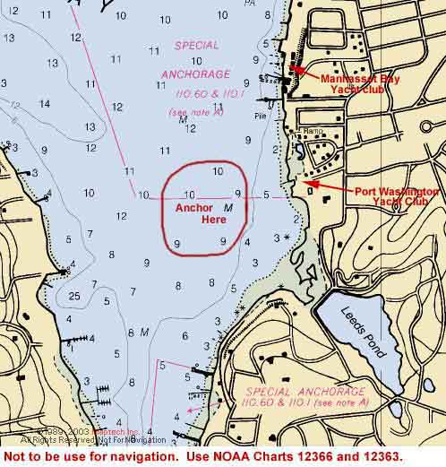
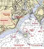
Friday, 7/30--Port Washington, Manhasset Bay, NY
Click on chart thumbnail
for details. Visit
MapTech.com! Visit
PortWashington.com!
Figure 1. Manhasset Bay – Port
Washington
Not to be used for navigation.
Use NOAA Charts# 12366 and 12363.
Plan on meeting in the late afternoon on Friday, July 30th.
Don't worry about when you should be there. There's no set
time. Just get there when you can. If you are first to arrive,
and the weather and seastate are calm, pick a place where
we can form a raft-up. If you don't want to be part of a raft-up,
that's fine too, just leave room for the other boats to raft
or anchor.
If conditions permit, let's form a raft-up in the area just
south of the mooring field across from the Port Washington
Yacht Club (Approx. 40°49'05"N 73°42'29"W.
Click on the chart thumbnail, Figure 1 above,
for details.). Mean tidal range is 7.3 feet.
Once settled, let's all get together on one boat or the raft
for snacks, cocktails and dinner. Bring one or two snack items
to share with the rest of the group and the fixin's for your
favorite beverage. Then it's potluck for dinner. No, we don't
throw everything into one pot and whatever comes out is dinner
(unless you want to). But whatever you bring it’s what
we'll have.
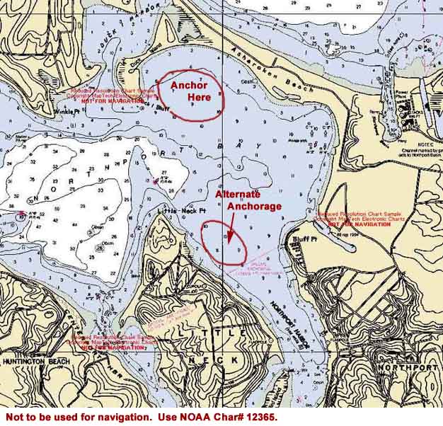
Saturday, 7/31--Asharoken Beach, Northport, NY -- 22 nm
Click on chart thumbnail
for details. Visit
MapTech.com! Visit
NorthPortNY.com!
Figure 2. Asharoken Beach and Northport
Not to be used for navigation. Use NOAA
Charts# 12365 and 12363.
It should be a leisurely sail from Port Washington to Northport
where we'll anchor in the bight off Asharoken Beach north
of Northport Harbor in 6-10' of water with a soft mud bottom
(click on the chart thumbnail, Figure 2 above,
for details) If there's a strong southwesterly, we'll anchor
north of the mooring field in Northport Harbor
off Little Neck and south of Asharoken Beach, instead. Mean
tidal range is 7.3 feet.
G"1" Fl G 4s off the long spit of West Beach marks
the entrance to Northport Bay, due E of Lloyd Harbor. Northport
Bay leads to Price Bend, Centerport Harbor, Northport Harbor
and Duck Island Harbor. The Asharoken Beach anchorage is approximately
1.8 nm east of G"1" Fl G 4s at the entrance of Northport
Bay and approximately 22 nm from the flotilla's previous destination
of Port Washington on Manhasset Bay.
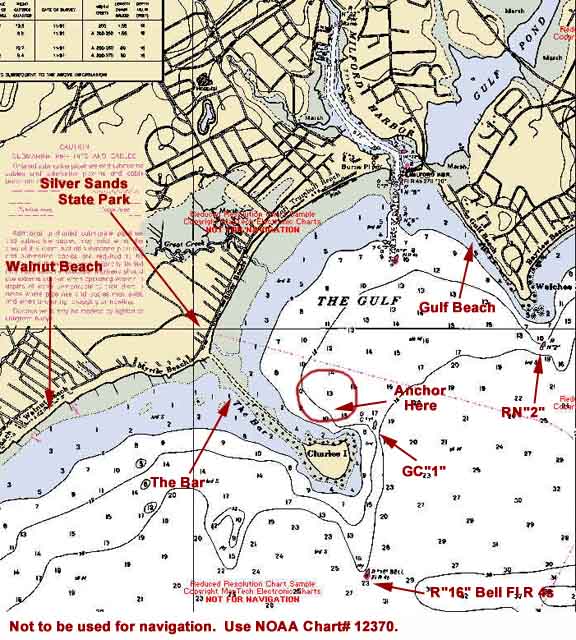
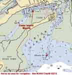
Sunday, 8/1--Charles Island, Milford, CT – 26.5 nm
Click on chart thumbnail
for details. Visit
MapTech.com! Visit
MilfordCT.com!
Figure 3. Charles Island, Milford, CT
Not to be used for navigation. Use NOAA
Charts# 12370.
From Asharoken Beach our next stop is another pretty but exposed
anchorage -- Charles Island.
If the weather is unsettled or the wind is out of the east,
we'll head up the river to Milford
Landing Marina (203-874-1610,
VHF Ch. 9, dockage $2.50 per foot). Otherwise will be meeting
in the afternoon on Sunday, August 1st and forming a
raft-up, if possible, in the anchorage north of Charles Island
(click on the chart thumbnail, Figure 3 above,
for details) in The Gulf, Milford, CT in 10-15' of water with
a hard sand bottom - softer near shore. Mean tidal range is
6.6 feet.
GC "1" at Charles Island is approximately 26.5 nm
from our previous destination of Asharoken Beach on Northport
Bay, approximately 5 nm NE of Stratford point and about 6.5
nm W of the channel entrance between the New Haven Harbor breakwaters.
Be careful of the shoals to the east and south of Charles Island
between R"16" Bell Fl R 4s and GC "1".
CAUTION: At high tide you may see local boaters cutting across
"The Bar" which connects Charles Island to Silver
Sands State Park on the mainland. DO NOT CROSS THE BAR. Enter
The Gulf between GC "1" (Charles Island) and RN "2'
(Welches Point).
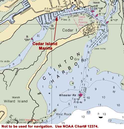
Monday, 8/2 --Clinton, CT – 25.3 nm
Click on chart thumbnail
for details. Visit
MapTech.com! Visit
ClintonCT.com!
Figure 4. Clinton, CT
Not to be used for navigation. Use NOAA
Charts# 12374.
Our next destination is Clinton, CT. We will
be meeting in the afternoon on Monday, August 2nd
at Cedar Island
Marina (860-669-8681, ext. 15, VHF Channels 9/68,
dockage is $2.80 per foot), Clinton, CT. (Click on the chart
thumbnail, Figure 4 above, for details.)
Please contact Cedar
Island Marina ASAP to reserve a slip.
Mean tidal range is 4.5 feet.
G"3" Fl G 4s, Wheeler Rock, the entrance to Clinton
Harbor, is approximately 25.3 nm E of our previous destination
of Charles Island at Milford, approximately 3.8 nm W of the
entrance to Westbrook Harbor and 6.2 nm E of the approach to
Guilford Harbor at Half Acre Rock. Mattituck Inlet on Long Island
is 14.8 nm to the SSW.
CAUTION: The entire area around Hammonasset Point develops
a nasty chop from tide rips.
Here we'll have a chance to top off our fuel and water tanks,
get our holding tanks pumped out, and luxuriate in the shower.
There's also a nice restaurant at the marina if your crews are
tired of hotdogs and peanut butter and jelly sandwiches.
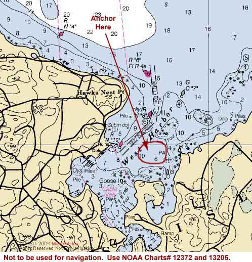
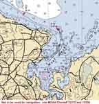
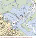
Tuesday, 8/3--West Harbor, Fishers Island, CT – 26 nm
Click on chart thumbnail
for details. Visit
MapTech.com! Visit
FishersIsland.net!
Figure 5. West Harbor, Fishers Island
Not to be used for navigation. Use NOAA
Charts# 13214, 12372 and 13205.
Next we'll drop our hooks outside the mooring field in West
Harbor on the northwestern shore of Fishers Island. Fl R 4s
R"6" marking the entrance channel at Hawks Nest Point
is approximately 3.9 nm from New London Ledge Light, 2.8 nm
from QG 22ft 8M "5" Morgan Point in Noank and 26 nm
east of Clinton, CT. (Click on the chart thumbnail, Figure
5 above, for details.)
West Harbor is the best anchorage at Fishers Island. The bottom
is a composite of grass, gravel and mud. Mean tidal range is
2.3 feet. Be mindful of Lewis Rock, marked by GC"7".
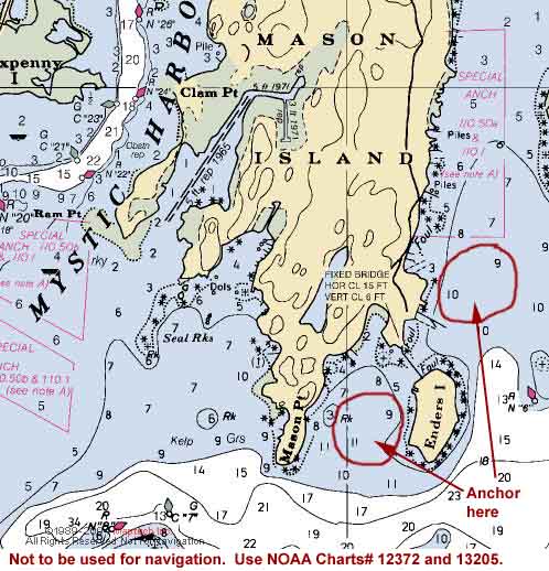
If the weather is out of the north or strong from the west
we'll use the anchorage south of Mason Island between Mason
Point and Enders Island or we'll anchor just south of the mooring
field on the east side of Mason Island approximately 3.5 nm
northeast of West Harbor. (Click on the chart thumbnail, Figure
6 below, for details.)
Click on chart thumbnail
for details. Visit
MapTech.com! Visit
Mystic.CT.US!
Figure 6. Mason Island, Mystic Harbor
Not to be used for navigation. Use NOAA
Charts# 13214, 12372 and 13205.
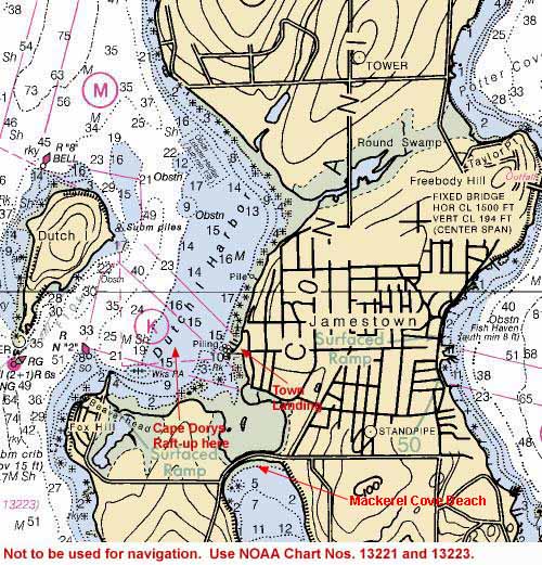
Wednesday, 8/4--Dutch Harbor, RI – 35 nm

Click on chart thumbnail
for details. Visit
MapTech.com! Visit
JamestownRI.com!
Figure 7. Dutch Harbor, Jamestown, RI
Not to be used for navigation. Use NOAA
Charts# 13221 and 13223.
We'll depart West Harbor as early in the morning as possible
(there may be fog) and contine sailing eastward north of Fishers
Island and head for Watch Hill Passage.
We will be meeting in the late afternoon on Wednesday, August
4th and forming a raft-up in Dutch Harbor, Jamestown,
RI on the western side of Conanicut Island in "general
anchorage K" north of the mooring field in the bight
north of Beaverhead, 35 nm from West Harbor on Fishers Island,
12.5 nm WNW of Third Beach on the Sakonnet River, 10.5 nm from
Newport, and 13.7 nm from Point Judith. (Click on the chart
thumbnail, Figure 7 above, for details.) Mean
tidal range is 3.5 feet.
Stay about 300 yards offshore of Beaverhead, keeping RN "2"
to the south. Beaverhead is a restricted conservation area.
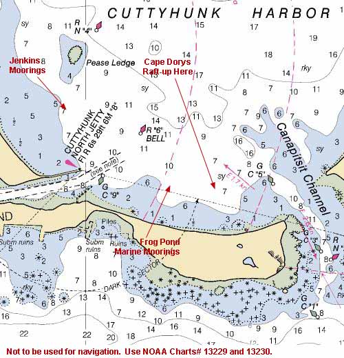
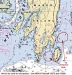
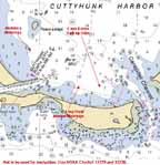
Thursday, 8/5--Cuttyhunk, MA – 30 nm
Click on chart thumbnail for
details. Visit
MapTech.com! Visit
Cuttyhunk.net!
Figure 8. Cuttyhunk Harbor
Not to be used for navigation. Use NOAA
Charts# 13229, 13230 and 13218.
From Dutch Harbor it should be a lively sail to Cuttyhunk,
the southwesternmost of the Elizabeth Islands.
We will be meeting in the afternoon on Thursday, August
5th in Cuttyhunk Harbor, between Cuttyhunk Island,
MA and Canapitsit Channel in the area outside the
Frog Pond Marine Moorings between R"6" Bell and GC"5".
(Click on the chart thumbnail, Figure 8 above,
for details.) But you may want to call in advance for a mooring.
Moorings are available in the Harbor from Frog Pond Marine
Moorings (508-992-7530, VHF Ch. 72) and Jenkins
Moorings (508-996-9294, VHF Ch. 9). Both of these
mooring fields are located in Cuttyhunk Harbor northeast of
the island. If you'd rather seek shelter in protected Cuttyhunk
Pond, moorings are available from the Town Wharf/Cuttyhunk
Marina (508-990-7578, VHF Ch. 9/10).
Cuttyhunk is the southernmost island in the Elizabeth Islands
chain. The Harbor lies between Cuttyhunk and Nashawena Island
to the east. To the west of the harbor there's a narrow dredged
channel that leads to the deep water basin of Cuttyhunk Pond.
Cuttyhunk Harbor is approximately 3.5 nm from Quicks Hole, 6
nm across Buzzards Bay from New Bedford, 7.5 nm from Menemsha
Bight on Martha's Vineyard and aproximately 30 nm from our previous
destination, Dutch Harbor, RI..
From the north it is best to approach Cuttyhunk from the east.
Steer toward Mo(A) Bell RW "CH", SE of Penikese Island,
then cut between RN "2E" and GC "1E" into
the harbor. From the east or south via Vineyard Sound, head
into Buzzards Bay via Quicks Hole between Nashawena and Pasque
Islands.
DO NOT use Canapitsit Channel, which separates Cuttyhunk
from Nashawena Island, without local knowledge. The channel
is narrow, rocky and subject to stong currents making the passage
dangerous.
Mean tidal range is 3.4 feet.
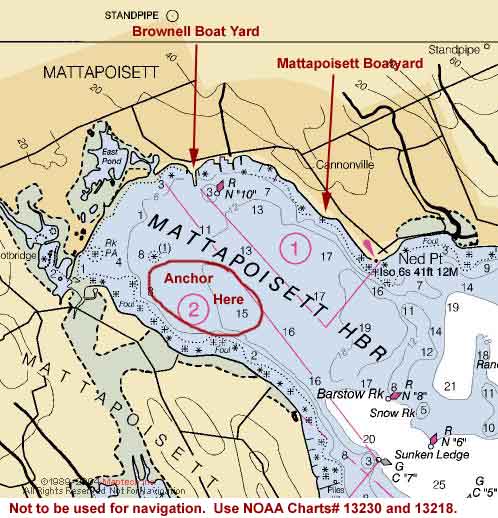
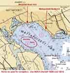
Friday, 8/6--Mattapoisett, MA – 17 nm
Click on chart thumbnail
for details. Visit
MapTech.com! Visit
Mattapoisett.net!
Figure 9. Mattapoisett Harbor
Not to be used for navigation. Use NOAA
Charts# 13230 and 13218.
From Cuttyhunk we'll sail up into Buzzards Bay and stop at
Mattapoisett. (Click on the chart thumbnail,
Figure 9 above, for details.) Here we'll have
another chance to top off our water and fuel tanks, get pumped
out, and go ashore. If the prevailing southwesterlies live up
to their reputation, we'll make short work of it. Mattapoisett
Harbor is a beautiful port. It's about 17 nm from Cuttyhunk,
11 nm from New Bedford and 8 nm from Woods Hole Passage.
Make sure to stay 1 nm offshore to pass south of BELL R "2SE"
off West Island in Buzzards Bay, then head northeast for Fl
G 4s BELL G "13" at Nye Ledge being sure to stay south
of Cormorant Rock. After passing Nye Ledge turn northwest and
follow the buoys into the harbor. Mean tidal range is 3.9 feet.
Anchor in Molly's Cove or moorings are available from Mattapoisett
Boatyard (508-758-3812, VHF Ch.
68) and Brownell
Boat Yard (508-758-3671, VHF Ch.
9).
If you need to reprovision, the Tedeshi Market (Rte. 6 between
Pearl and Barstow streets) carries basic grocery items, and
the Village Package store is nearby. Shipyard Galley on Water
Street has a selection of baked goods as well as as soup and
sandwiches and around the corner from Mattapoisett Boatyard
you'll find Porky's Quality Meats.
Saturday and Sunday, 8/7 and 8/8--Aucoot Cove, MA – 5.5
nm
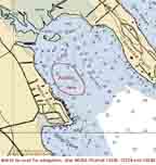
Click on chart thumbnail
for details. Visit
MapTech.com!
Figure 10. Mattapoisett Harbor
Not to be used for navigation. Use NOAA
Charts# 13230 and 13218.
Aucoot Cove is just a short hop and a skip
from Mattapoisett Harbor. (Click on the chart thumbnail, Figure
10 above, for details.) Here we'll meet up with the
boats participating in the Buzzards
Bay Float-in so we'll spend the next two days visiting
with the other crews and getting ready for our trip through
the Cape Cod Canal on Monday. If the weather is unsettled we'll
stay in Mattapoisett Harbor.
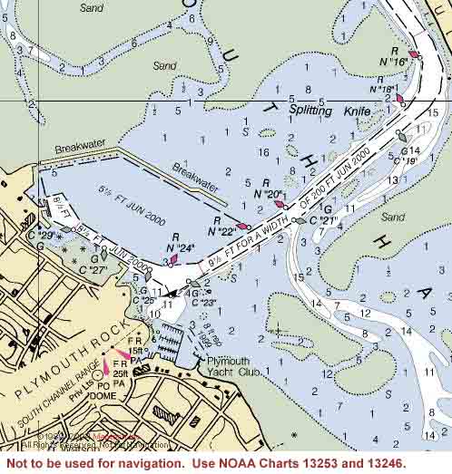
Monday, 8/9--Plymouth, MA – 32 nm
Click on chart thumbnail
for details. Visit
MapTech.com! Visit
TownOfPlymouth.org!
Figure 11. Plymouth Harbor
Not to be used for navigation. Use NOAA
Charts# 13253 and 13246.
The predicted time for the current to turn east (flood) on
the Cape Cod Canal is 11:02 a.m.
Monday morning. Plan on departing the anchorage in Aucoot Cove
at 9:30 a.m. This should give us a fair tide
through the canal and an arrival time in Plymouth at around
3:30 or 4:00 p.m.
At Plymouth the flotilla arrives at its final destination and
meets up with the other boats participating in Cape
Dory Rendezvous 2004 (click here for rendezvous
details) at the Plymouth Yacht Club.
2004
Tide and Current Predictions: Cape Cod Bay, Cape
Cod Canal, Bournedale
|